Woods Hole Group solves environmental engineering problems worldwide with a focus on serving clients along the coast, in the ocean, and in wetland and terrestrial environments. Relying on service, excellence, and leadership, our experienced engineers, scientists, and technicians – along with over 30 years of experience – we work to exceed client objectives while safeguarding the environmental health of our planet. Founded in 1986, Woods Hole Group joined the CLS Group in 2017. Today, Woods Hole Group has nearly 100 employees, with our corporate headquarters on Cape Cod in Massachusetts and client-centered regional offices in Delaware, Maryland, and Texas.
Our Sustainable Fisheries Management Business Unit operates in three primary areas: Tracking and Monitoring, Catch and Quota Management, and Ocean Intelligence, with product lines composed of satellite and cellular vessel monitoring systems (VMS), e-logbook applications, fisheries monitoring centers, ocean intelligence products, and IUU intelligence services based on the cross-analysis of VMS, AIS, radar, and optical imagery.
Tracking and Monitoring
Since the beginning of the program, Woods Hole Group has been a type-approved VMS supplier in good standing with National Marine Fisheries Service (NMFS) and NOAA (National Oceanic and Atmospheric), currently tracking over 3000 vessels daily, 24x7x365. We do this using two state of the art VMS tracking beacons: the Triton Advanced and the NEMO.
Triton Advanced VMS
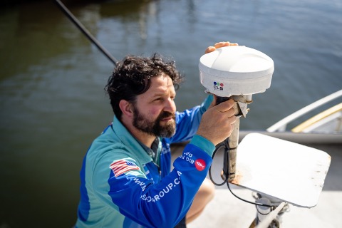
Our Triton Advanced VMS is primarily for federally permitted industrial fishing vessels and utilizes the Iridium Satellite Network for connectivity and communication. This allows for real-time, global vessel tracking and catch monitoring. The Triton Advanced system is comprised of the beacon dome that houses the Iridium antenna, a junction box for powering the unit and connecting sensors, and a ruggedized Android tablet that communicates with the junction box via Bluetooth. Through the Bluetooth tablet and Iridium network, captains can send emails, check weather reports, and submit catch or electronic form data in real time from anywhere on earth. These catch reports contain important species and biomass tonnage statistics which are closely overseen by NMFS to maintain a sustainable fishery year after year. Triton has been proven in the world’s toughest conditions ranging from the Bering Sea to the Equator and continues to lead the industry in reliability, feature set, and is the VMS system-of-choice of over 40 governments and/or fisheries regulatory bodies around the world.
Nemo VMS
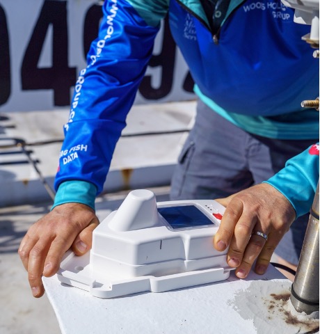
The NEMO VMS was introduced to the US market in 2021 as a low cost, hybrid tracking solution for coastal fisheries. The NEMO features cellular connectivity for low-cost vessel tracking and comes with a built-in satellite modem for backup distress alerting over the global coverage ARGOS 2 satellite network. NEMO is also future compatible with the soon-to-be launched nanosatellite constellation, KINEIS, providing true two-way communication in near real time anywhere in the world at a price point previously thought impossible.
The NEMO is easily installed with only 5 screws and can be powered by both on-board vessel power and through the built-in solar panel.
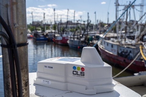
Thus far, we have deployed approximately 500 NEMOs in US waters, primarily into the SEFHIER (Southeast For-Hire Integrated Electronic Reporting) program in the Gulf of Mexico. Participating charter fishermen in the program are choosing the NEMO for its low cost, ease of installation, reliability, and — with the Gulf of Mexico sun — incredible battery life.
The future looks bright for NEMO to be featured in emerging coastal, regional, and small-scale fisheries applications in need of low-cost fisheries management science tools.
Catch and Quota Management
Custom Catch Reporting
As we enter the era of modern catch reporting and data management, Woods Hole Group is helping fishermen modernize and optimize their data flow with full paper-to-digital transformations. Our catch reporting system provides an all-in-one solution for fishermen of every level, from a weekend charter fisherman in the Gulf of Mexico to a groundfish vessel in the Northeast (one of the most heavily regulated fisheries in the world). CLS and Woods Hole Group’s proprietary systems and data security protect the fisher’s data every step of the way, from entering the catch information on the tablet, to being sent over the satellite network, to our secure servers, to finally being delivered to the appropriate scientific or regulatory body.
We also work with fishing companies to modernize their operations. Our in-house team of software developers create custom reporting solutions, which transform decades old, manual pen-to-paper reports into seamless, automated operations powered by state-of-the-art technology.
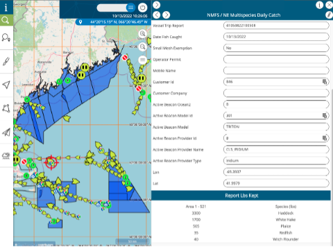
In addition to developing and building VMS hardware and catch reporting solutions, we provide a way for our customers to view the data produced by these technologies. In use for over 15 years, THEMIS (Thematic Maritime Information System) is an online platform that integrates multiple sources of marine data (radar, AIS, VMS, catch reports, and oceanography). Through this interface we can create geozones that interact with VMS beacons to alert fishermen and/or regulators when transiting into or out of specific areas such as closed areas, marine protected areas, or experimental fishing grounds. Users can also create their own zones for use in their own operations.
While this platform is available to all Woods Hole Group VMS users, a more robust version of THEMIS is available to Fisheries Monitoring Centers who wish to not only see VMS positions, but an entire database of ships with accompanying information (such as identifiers, vessel name and characteristics, owner name, and licenses). Also, Themis now includes an e-logbook module with complete catch analytics for fisheries administrators (statistics by vessel, fleet, zone, fish type, quota management), providing real time reports for quick action zone and resource management. Finally, THEMIS can be hosted at our CLS headquarters in Toulouse, France, eliminating the need for infrastructure or maintenance on premises.
Ocean Intelligence
An exciting area of development for Woods Hole Group is the growth in our suite of Ocean Intelligence software.
CATSAT
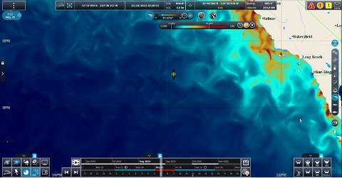
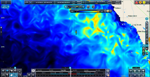
A staple in the modern fishermen’s tool kit for the last decade, CATSAT (Color, Altimetry, Temperature via SATellite) helps locate target species while simultaneously reducing bycatch, search time, and operating costs. Installed on board the vessel, and combining satellite, model, and in situ data, CATSAT allows fishermen to see through the water column in real-time to make educated decisions on fishing areas and conditions.
Until now, CATSAT has been relied upon to provide the highest resolution oceanographic data in altimetry, surface and subsurface temperature and salinity, and thermocline depth and gradient. In our latest version, CATSAT v6, we have debuted game changing data and models providing even more accurate fishing recommendations. We are proud to be the only supplier capable of providing real time biological data on plankton, zooplankton, and micronekton, effectively breaking down and displaying the entire food chain for most pelagic predators.
Fishermen can now make better-informed decisions on where to fish for target species, reduce bycatch and improve operational efficiencies. Also, in CATSAT v6, we have introduced an all-new buoy & FAD tracking module, even higher resolution weather and wind data from both the NCEP and ECMWF models, plus, fishermen can still count on a powerful integrated catch logbook with filter and gradient tools for analysis. Finally, WHG and CLS are proud to employ a full-time team of in-house oceanographers to assist customers with fishing recommendations and product support.
DOLFIN
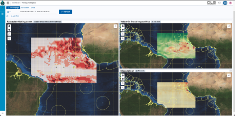
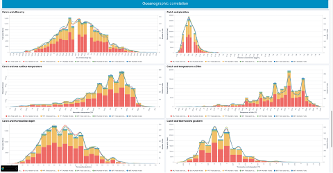
Our newest product release, DOLFIN (Data for Oceanographic Learning and Fisheries Intelligence Needs), harnesses the power of machine learning and artificial intelligence to accurately predict and identify the best fishing zones for target species and bycatch avoidance. We do this by correlating historical catch data with oceanographic data to understand what conditions were present at the time and location of the catch. By using VMS and catch logs, we can pair the catch to a specific date, time, and location and correlate it against the decades of oceanographic data we have collected and archived for use in CATSAT. After our data set is built, we can begin to manipulate it with powerful filters and analysis tools to further understand the performance. We can also compare vessels within a fleet and draw conclusions on why a certain vessel may outperform others. This benefits bycatch species as well, as we can specifically choose areas and conditions that our target species prefer, and where bycatch is unlikely to be present.
On The Horizon
Woods Hole Group’s long-standing commitment to sustainable fisheries management is both a key to our history and our future as a service provider. We strongly believe environmental leadership is defined by creativity and vision – that human and economic development are not separate and that both can be achieved in harmony with a sustainable planet. We are excited that new, cost-effective technologies are creating new opportunities and removing legacy barriers to entry. As those barriers come down, we’ll work with NGOs, regulators, and industry stakeholders to promote these exciting new technologies and improve management of our precious natural resources.
With the tools described above, fishermen and managers can reliably, efficiently, and accurately report vessel positions and catch data, and sustainably manage fleets on the fishing grounds. Coupled with the power and reach of the global CLS network, our customer service team are providing dedicated technical support and training to thousands of stakeholders every day, including industry members and regulators alike. Our technical support team sits in the WHG Lanham, Maryland office and is always available to meet our client’s day-to-day technical needs. CLS and Woods Hole Group’s Sustainable Fisheries Management team will continue to lead the industry and develop innovative maritime technologies that help combat illegal fishing and solve real-world problems for industry members and regulators alike.
Jason Surma is Business Development Manager in Woods Hole Group’s Sustainable Fisheries Management Unit. He is happy to hear from readers here. To highlight your company in a future Industry Focus feature, please drop us a line at info@em4.fish. And to read past articles in this series, please visit our Feature Articles Archive.
